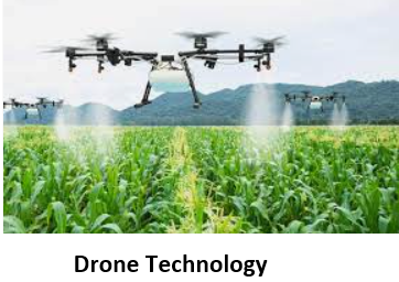
HOW DOES DRONE TECHNOLOGY WORK?
Only after complete recognition of drones characteristics can one gain in-depth knowledge about agriculture drones. Typically, drones include a navigation system, GPS, multiple sensors, high-quality cameras, programmable controllers, and tools for autonomous drones. The DJI is one such familiar drone utilized by the industry. Most farmers currently use satellite imagery as an introductory guide for farm management. Furnished with modern technology, Unmanned aerial vehicles (UAVs) can get more precise data than satellites for precision agriculture. They then process the data captured into agri-tech software to produce beneficial knowledge
Capturing data from agriculture drone takes place as in the following stages
- Analyzing the area: This identifies the territory being tested. Therefore, the first step includes establishing a boundary, analyses of the area, and then finally, uploading the technical GPS information into the drone’s navigation system.
- DATA PROCESSING
Using Autonomous Drones: Since Unmanned aerial vehicles (UAVs) are independent, they enter flight patterns into their already established system to collect required data.
Uploading the data: After capturing all the required data through sensors such as the multispectral sensor/RGB sensor, it is processed through numerous software for further analysis and interpretation.
Output: After collecting the data, they format it so that farmers can understand the data with no hassle, bringing them a step closer to precision farming. 3D mapping or Photogrammetry are popular methods to display extensive data collected.
BEST DRONE PRACTICES
Drone technology quickly reestablishes traditional agrarian practices and is subsequently accomplishing them as follows:
- IRRIGATION MONITORING: Drones, including hyperspectral, thermal, or multispectral sensors, recognize areas that are too dry or need improvement by the farmer. Drone survey helps improve water efficiency and disclose potential pooling/leaks in irrigation by providing Irrigation monitoring yields calculations of the vegetation index to help realize the health of crops and emitted heat/energy.
- CROP DAMAGE ASSESSMENT: Agricultural drones fitted along with multispectral sensors and RGB sensors also detect field areas inflicted by weeds, infections, and pests. According to this data, the exact amounts of chemicals needed to fight these infestations are known, and this helps diminish the costs inflicted by the farmer.
- PESTICIDES SPRAYING: Through drone crop spraying, human contact with such harmful chemicals is limited. Agri-drones can carry out this task much quicker than vehicles/airplanes. Drones with RGB sensors and multispectral sensors can precisely identify and treat problematic areas. Professionals say that aerial spraying is five times faster with drones when compared to other methods.
BENEFITS OF DRONE TECHNOLOGY
As innovators introduce new technologies, their commercial uses increase day by day. The government has been easing restrictions for drone usage and is supporting startups to come up with novel ideas. As drone surveys become more common, they also become more cost-effective. In agriculture, they have a plethora of advantages. Some are as follows:
- Enhanced Production – The farmer can improve production capabilities through comprehensive irrigation planning, adequate monitoring of crop health, increased knowledge about soil health, and adaptation to environmental changes.
- Effective and Adaptive Techniques – Drone usage results in regular updates to farmers about their crops and helps develop strengthened farming techniques. They can adapt to weather conditions and allocate resources without any wastage.
- Greater safety of farmers – It is safer and more convenient for farmers to use drones to spray pesticides in terrains challenging to reach, infected areas, taller crops, and power lines. It also helps farmers prevent spraying the crops, which leads to less pollution and chemicals in the soil.
- 10x faster data for quick decision-making – Drone surveys back farmers with accurate data processing that encourages them to make quick and mindful decisions without second-guessing, allowing farmers to save the time invested in crop scouting. Various sensors of the drone enable capturing and analyzing data from the entire field. The data can focus on problematic areas such as infected crops/unhealthy crops, different colored crops, moisture levels, etc. The drone can be fixed with several sensors for other crops, allowing a more accurate and diverse crop management system.
- Less wastage of resources – Agri-drones enables optimum usage of all resources such as fertilizer, water, seeds, and pesticides.
- 99% Accuracy rate – The drone survey helps farmers calculate the precise land size, segment the various crops, and indulge in soil mapping.
- Useful for Insurance claims – Farmers use the data captured through drones to claim crop insurance in case of any damages. They even calculate risks/losses associated with the land while being insured.
- Evidence for insurance companies – Agricultural insurance sectors use Agri-drones for efficient and trustworthy data. They capture the damages that have occurred for the right estimation of monetary payback to the farmers.